Snowcover within the Kibo
caldera may have reached an annual minima last week. The two-image
Sentinel-2 timelapse above shows the same area, five days apart.
The mostly cloud-free image on 4 November depicts the largest extent of
snowfree area for calendar year 2020. Nonetheless, note the extensive
snowcovered area east of the Northern Icefield and north of Reusch
Crater; this was evidently an area of higher accumulation during the
previous wet seasons. South of Reusch Crater, white areas within the
caldera are all patches of snow - with the exception of one remaining
fragment of Furtwängler Glacier, the east-west oriented body just south
of the extensive snowfree area. On the caldera's south side, snowcover
blankets the south-southwest facing slope and delineates the rim,
closely paralleling the trail from Stella Point to Uhuru Peak.
Encompassed within this area are the upper fragments of Kersten and
Deckens Glaciers, with less-continuous snow around the Rebmann Glacier.
Below the upper south-side glaciers is a steep, 100-150 m band without
snow, then patchy snow and the snowcovered lower fragments of the
Kersten and Deckens Glaciers.
Snow blankets the entire upper portion of the mountain on 9 November, as
visible in the second image (despite a thin cloud veil). This snowfall
event is "right on schedule" in terms of the precipitation climatology
for high elevations of Kilimanjaro. This would be a fascinating time to
be up there, for a survey of snow depth and spatial variability...
Thursday, November 12, 2020
Seasonal change
Sunday, October 25, 2020
Fires extinguished, snowcover continues to decrease
I hear from friends in Mweka
that wildfires on the mountain are now out, thanks both to some rain,
and hard work by personnel. They burned quite close to the Mweka (descent) trail, just above the upper forest line, a zone which has been severely impacted by fires and climate change in recent decades (see Andreas Hemp reference within this link). A helicopter pilot from Kenya was able to
provide valuable assistance to firefighters for several days.
Today's satellite image - and that of 20 October - shows considerable
cloud cover on the mountain, as expected at this time of year. A "hole"
in the clouds does reveal the caldera's west side, and much of the
Breach, to now be snowfree.
The next clear view of the mountain will be posted here. Will any
seasonal snow persist to the next period of accumulation? Stay tuned!
Thursday, October 15, 2020
Serious wildfires continue [updated]
This morning's Sentinel-2 image of Kilimanjaro reveals the seriousness
of fires burning since Sunday, high on the mountain (bands 12, 11, and
4). Reports suggest the fire was started accidentally along the Marangu
Route. Early reports from TANAPA expressed premature optimism that "the
fire is already under control" (14 Oct. via @tzparks), yet Minister of
Natural Resources and Tourism, Hamisi Kigwangalla, is quoted in the NY Times today: "the task is harder and bigger than it is thought to be".
On the false color image above, note the Reusch Crater. Snow and ice
appear royal blue, with burning areas in yellow-red. This is a very
serious, extensive fire! Smoke is visible being blown westward from the
fires, burning at an elevation above 3000 m. The dominant vegetation
type at this level is giant heather (Erica excelsa), which ecologist
Andreas Hemp describes as "an obvious fire sign" which "enhances the
fire risk, as even fresh Erica wood burns well". As highlighted in a
UNEP posting based on Hemp's work, "nearly 15% of Kilimanjaro’s forest
cover was destroyed by fire since 1976 and was replaced by Erica bush
which extended its total area by 5km2 (mainly downslope)."
The upper portion of the popular Marangu Route is shown in green,
passing Horombo Huts where some fire damage may have occurred. One
updated account today (here) quotes Minister Kigwangalla as saying that
yesterday's rebound "destroyed the Horombo Tourist Camp, including 12
huts, two toilets, and solar equipment". The mountain's primary descent
route past Barafu Camp is also shown, appearing to be threatened by both
fire and smoke.
We await first-hand reports from the mountain, and welcome any additional information.
[UPDATE 10/16: Our friend Timba (Travel Consultant in Moshi) sent a link depicting Carbon Monoxide concentration, via the Earth website. Although the screenshot below does not show the data well, note the value for Kilimanjaro of 13,116 parts per billion by volume (high enough to cause chronic problems with long-term exposure - from CO alone).]
Tuesday, September 15, 2020
Processes in opposition
Light accumulating snowfall is common at this time of year, as is its subsequent ablation within a few days. These opposing processes are especially critical for the glaciers as the dry season concludes, because albedo reaches an annual minimum while temperature, humidity, and solar radiation are all increasing.
In today's image (not shown), partially obscured by clouds, the dusting of snow seen above has completely ablated, and snowcover within the caldera is patchier yet.
While it appears that areas of snow will endure the dry season this year, failure of the short rains - or even a delayed onset - might yet ablate much of the lingering summit snow.
Wednesday, September 9, 2020
What Will Gadd learned on top of Kilimanjaro
Red Bull today released a fantastic new Will Gadd film, shot with a full crew during our pre-COVID February trip. The finished product (45 minutes) is about extreme sport, but also about the science of Kilimanjaro glaciers and climate change; it is well worth watching.
Will was a joy to work with - as eager to learn and share knowledge as he is to climb ice - and clearly articulates the responsibility we all have to reduce our carbon impact. Red Bull deserves major credit for broadening the scope of their productions. And, the stuff is tasty!
Director Tom Beard and the KEO Films crew did a wonderful job of editing, and eagerly accepted ideas to insure an accurate result.
Access the film here: <https://redbull.com/thelastascent> or here.
Wednesday, September 2, 2020
31 August snowcover
Snowcover continued to
decrease during the last 5 days of August, as the image below reveals
relative to that from 26 August (previous post). Change appears most
evident in the northwest corner of the caldera. Nonetheless, the extent
of snow at the summit remains more than average - with perhaps two
months remaining in the extended dry season.
Tourism on the mountain remains minimal, as the new Coronavirus pandemic
continues. For example, the Machame register book shows only 58
climbers departing for the normally-busy months of July and August.
Our friend Simon Mtuy and a large SENE team have been assisting in a
large clean-up operation. Over just two days, SENE staff collected 45
kilos of trash from the Machame Camp area. Simon reports that this week
there will be 400 crew from 16 companies helping in the clean-up, which
will include the Western Breach route and the Crater Camp area. Asante
sana!
Monday, August 31, 2020
Snowcover at the end of August
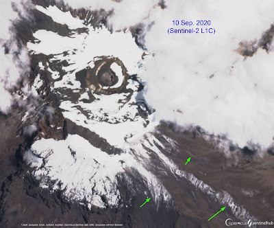
Snowcover in the caldera has
been decreasing through August, and is now at roughly 75% by area. The
image above was acquired by Sentinel-2 on the 26th. Although it now
appears possible to reach Stella Point without ascending on snow,
considerable snow remains in some places, such as to the east of the
Northern Icefield.
During the boreal summer months of June-August, when the sun is in the
northern hemisphere, less solar radiation is received on any slope
inclined to the south. Note the extent of snowcover remaining on the
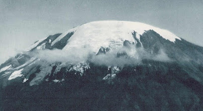
mountain's southern slopes (above). This area coincides with
where the Southern Icefield used to exist - illustrated below during
Walter Mittelholzer's flight over the mountain in January 1930. Whereas most
of the white area in 1930 is snow over glacier ice, very little ice
remains on the south side in 2020.
(Preservation of seasonal snow on the south side is not solely a
function of aspect. The spatial pattern of snowfall on the mountain
between November 2019 and June 2020 is not known (and was likely not
uniform), and snowcover retention is also governed by the seasonal distribution and extent of cloud cover.)
Below: Mittelholzer's Fokker F.VIIb-3m "Switzerland" refueling enroute to Kilimanjaro [credit].
Wednesday, August 5, 2020
Meteorological gradients on Kersten Glacier
Anchoring the analysis are measurements made at two automated weather station sites, shown as #3 and #4 on the photo above (taken July 2005 by co-author Nicolas Cullen). The stations span 270 m in elevation; both were installed and operated by the Univ. of Innsbruck team, who have coordinated numerous analyses and publications emphasizing AWS 3 (e.g., Mölg et al., 2009). This new ESD paper uses data from a four-year interval of overlapping measurements (2009-2013), including the 2010 El Niño event.
Besides the empirical knowledge provided by analysis of the AWS datasets, the paper links measured on-glacier gradients to a high-resolution atmospheric modeling data set (Emily Collier), while also considering the large-scale geostrophic flow high on the mountain (~500 hPa).
This study illustrates the importance of field measurements, especially in environments threatened by climate change. Data such as these will endure forever, available for creative new analytical approaches and model validation. Sadly, the Kersten Glacier is no longer intact, now with a large gap between AWS 3 and 4. To the west (left on image above) the Heim Glacier is essentially gone, as is the Decken Glacier to the east (right). Replication of these measurements will never again be possible, due to the loss of ice at high elevations on the mountain...
Here is a link to the article (open access).
*Authors: Mölg, T., D.R. Hardy, E. Collier, E. Kropač, C. Schmid, N.J. Cullen, G. Kaser, R. Prinz, and M. Winkler
August snowcover
The Sentinel-2 image above was acquired on 1 August. Snowcover has thinned somewhat over the past couple months, revealing interesting textures of the relatively-flat ash within the caldera; note for example those between the Reusch Crater and Uhuru Peak. Might these lobate features be periglacial?
With bright snowcover on the glaciers, ablation has likely been minimal. This situation is similar to that of the 2018 dry season, when a 2 August image also shows nearly-complete snowcover within the caldera. In contrast, there was no snow at the summit last year at this time.
Another curious ablation feature is visible within the caldera, on the Reusch Crater's western slopes. The dark area of bare ground was not present during the snowy dry season two years ago, nor as the 2020 dry season began in June. The timelapse below starts towards the end of June, showing only this area west of Reusch Crater. Despite low resolution, the progressive growth of this spot is apparent. While it is tempting to speculate that enhanced, localized geothermal heat may be responsible, an explanation will require an examination of topography (e.g., aspect and slope) as well as the snow distribution pattern.
Lastly, trails are visible on the western slope (top image), between Shira Plateau and Lava Tower, then to Barranco Camp and continuing toward Karanga. Also visible - largely transverse to the trails - are stream channels which in recent years have been deepened and widened by debris flows. Look for a post soon with details on these.
Tuesday, June 9, 2020
AWS, long rains end, quiet mountain
Our friend Simon (SENE*) made a trip to the summit caldera recently, and has shared some photos. He kindly detoured his climb to visit the Northern Icefield AWS and inspect our instrumentation. The upper photo illustrates snowcover on the glacier at the end of February. The red circle highlights a replacement temperature/humidity sensor, which with luck is accurately measuring these important variables again.
The second image shows a net 'long-rains' snow accumulation of at least 50 cm. Aside from footprints, the surface texture suggests that a week or more has passed since the last snowfall. On the ascent, Simon estimates ~60 cm of snow beginning below the caldera rim.
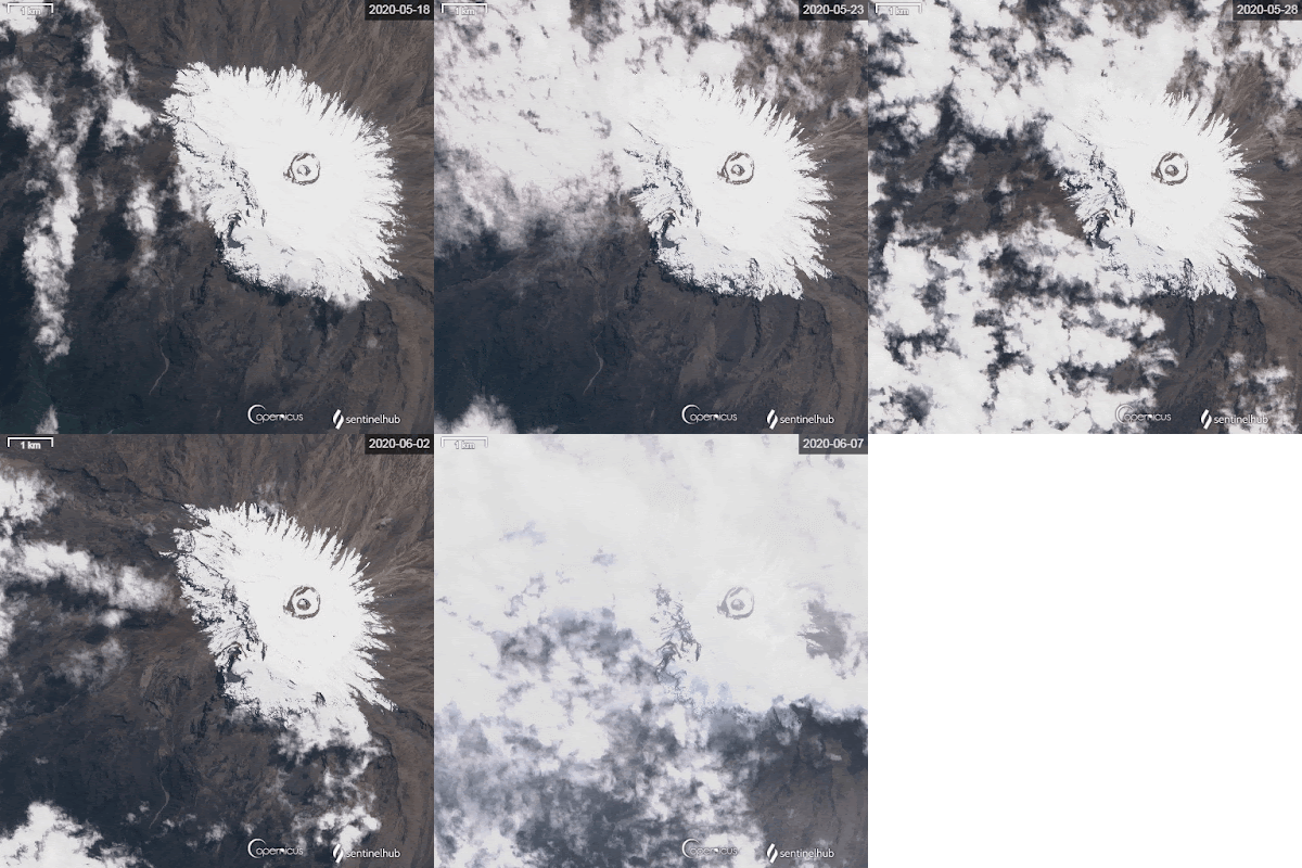
Below is a Sentinel-2 timelapse of snowcover between 18 May and 7 June. The transient snowline can be seen increasing in elevation, with thinning of snow on north-facing slopes. This pattern of ablation will likely continue in the months ahead, as rarely does the 'long-rains' season extend much into June.
Simon reports that the mountain is currently devoid of people. In the lower right-hand corner of the satellite image is a light-colored, circular area, which is "Barafu Camp" at 4,700 m. This is the last camp used by most climbers, and once the dry season gets underway it is bustling with hundreds of people. The lowest photo shows Barafu this year, with not a single tent visible; only camp infrastructure buildings can be seen.
*Tourism is severely impacting Tanzania, as the case with other destinations reliant upon international tourism. In preparation for a return to something approaching normal, SENE is offering special terms for future trips booked during June - safaris as well as Kilimanjaro climbs. #TravelTomorrow
Tanzania's President Magufuli has taken drastic steps to reopen the country, lifting the ban on flights and removing the required quarantine. Time will tell whether this early action was responsible...
Wednesday, April 29, 2020
Ski Africa!
From a satellite's perspective, Kilimanjaro emerged from thick cloud cover yesterday, revealing substantial snow blanketing the upper ~1300 m of the entire mountain (i.e., above about 4600 m / 15,100 ft). This is an area of ~50 km^2.
Distinguishing between fresh snow and thin, low clouds is difficult on this particular image - yet snowcover appears remarkably uniform. On such a big mountain, precipitation often varies spatially, reflecting interaction of the massif with regional circulation.
Not often is it possible to ski 1000+ meters at 3° south latitude. But if snow accumulation continues through May, as it typically does, this June might be a great time to ski the mountain - with appropriate COVID-19 precautions.
#seneadventures @christianpondella
Tuesday, April 14, 2020
April Update
 |
| Northern Icefield margin with "cloudcam" and AWS. At the edge, note the layer of seasonal snow overlying glacier ice (23 February 2020). |
Since the short rains diminished in January, a series of snowfall events have maintained fresh snowcover on the glaciers (see images above and below). Summit caldera snowcover has varied between continuous (see 3 Feb image) and patchy (as seen on yesterday's satellite image, above). Snowcover appears to have been gradually decreasing over the past two weeks, as also occurred during February until restored by early March snow.
In most years the long rains continue through May, ending rather abruptly by early June. Precipitation between now and then will determine what climbers encounter once travel and group climbs are safe again. Although recession of the glaciers continues, seasonal snowcover creates an illusion of permanence. At some point during the dry season though (June-September), the snow is likely to completely ablate and the bright ice will again be in stark contrast to the dark volcanic ash - reminding us that the ice will likely be gone within a few decades.
 |
| Residual ice with Mawenzi in the background. Note seasonal snow layer on the ice as well as the crater surface (25 February 2020). |
Monday, February 3, 2020
Stable weather returns [updated]
February weather on Kilimanjaro is often characterized by a dry interval, between the Short Rains of approximately Nov/Dec, and Long Rains within the Mar/Apr/May time period. As noted previously, the Short Rains brought considerable rain to the mountain this year, with snow up high, beginning in early October. That wet period appears to have ended.
The upper image from 2 February shows patchy snowcover on the upper 1000 meters of the mountain's south side, as viewed from above Moshi (Simon Mtuy credit). Distinguishing remnants of the former Southern Icefield from snowcover is difficult here.
The second image above was acquired today by the ESA Sentinel-2 satellite, revealing continuous snowcover within the summit caldera, and on the upper slopes. The stable-weather cumulus clouds visible here appear only slightly more extensive than those on the day before (top image).
Although telemetry of data from the Northern Icefield (NIF) weather station is not currently available (budget constraints), several recent reports from climbers confirm what the images depict. On 23 January, collaborator Sarah Konrad visited the NIF and measured a mean snowdepth of ~0.60 m around the weather station. Shortly thereafter (28 Jan.), Simon was above the Western Breach in the Furtwängler Glacier area, reporting "almost one meter of snow."
Images below show Simon's camp at Arrow Glacier on the 27th, looking south across the Western Breach, and a Furtwängler Glacier remnant near Crater Camp (Sarah Konrad credit). Finally, a photo of the NIF weather station from Sarah reveals that the equipment is overdue for a "service visit". Fortunately, planning is underway to visit the station later this month!
[UPDATE 02/04: Our friend Timba keeps close tabs on Kilimanjaro weather from Moshi, in the interest of safety for the many guides and porters working on the mountain. It was Timba who inspired our analysis of how tropical cyclones might influence snowfall on the mountain (Collier et al., 2019).
Timba wrote today, emphasizing how wet the region has been in recent months, especially at the end of September and through most of October 2019. As he points out, this is the time when the Indian Ocean Dipole (IOD) was very strongly positive, a water temperature pattern associated with heavy rain in eastern Africa - and bushfires in Australia (read more here and here).
So, has stable weather really returned to Kilimanjaro? Although the IOD has returned to a neutral pattern, older friends of Timba's equate the current rainfall pattern with that of Oct. 1988 to June 1989 - when the two rainy seasons merged into one long wet season.]


