Friday, October 7, 2022

Summit without snow

Kibo's summit is currently snow-free, towards the end of the dry season. The two images below from the ESA Sentinel-2 satellite show virtually no snow on the mountain - the typical situation at this time of year. Back in 1889 on his first ascent, Hans Meyer observed that "in October, when all the snowfields had disappeared, there was likewise comparatively little snow to be met with on the ice-cap". This was 133 years ago! These recent images below show clouds over the west and southwest flanks of Kibo, but other white areas are glacier ice.


Check back in mid-October to learn more about how these dry-season conditions, and why we were unable to visit the summit weather stations in September. Planning is already underway to get up there again though!


Thursday, July 28, 2022

Stable weather at the summit

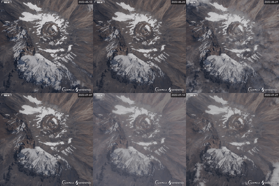
Two months into the 2022 dry season - roughly halfway through - the extent of snowcover has remained remarkably constant. The animation below runs from 12 June through 27 July at a five-day interval (22 July not shown due clouds).

Although mass loss continues, the low rate of ablation suggests cold and dry conditions at the summit, supported by the lack of convective clouds seen on these images. With such weather conditions, sublimation is the predominant mechanism of ablation, requiring eight times more energy per unit mass lost.

Typically, an increase in atmospheric moisture marks the transition between the dry season and short rains, yet for much of eastern Africa the pattern has been disrupted in recent years. David Nash details the current and forecast situation in a short article for The Conversation.

We will be back on the mountain in September! After a 2-year COVID hiatus, we are eager to observe the glaciers, recover meteorological data - and provide a new perspective on Kilimanjaro climate variability and change (stay tuned)!


Monday, June 6, 2022

Kibo 2022 Dry Season begins

Throughout eastern Africa the dry season is getting underway, a period of 4-5 months with minimal precipitation. June typically begins with complete snowcover on Kilimanjaro, resulting from the March-May rainy season, which in some years supplements January snowfall events as well as snow deposited during the November-December short rains. With reduced cloud cover and lower temperatures on the mountain during the dry-season months, snow gradually sublimates and melts. This annual cycle of snowcover was roughly defined by the late 19th century:

Although Kilimanjaro lies near the equator the extent of its ice and snow varies with the season. The southern summer (December to May) is also the rainy season in the Kilimanjaro region, and it is then that the accumulations of ice and snow are greatest. In the southern winter (June to November) there is a comparative dearth of moisture, the snowfall is proportionately slight, and the process of melting goes on rapidly; hence, by the end of the season, the accumulations of ice and snow are at their smallest.
   
Hans Meyer, Across East African Glaciers (1891)
Snow currently blankets only about half of the summit caldera, and only the southern flanks - as illustrated on the satellite image above, from last week (2 June). Within the caldera, this pattern of accumulation has remained quite consistent through the 2022 long rains. More noteworthy is that accumulation is clearly less than normal. Compare this year's snowcover with that of 2020 and 2018 in these images:

In a larger spatial context, snowcover on Kilimanjaro following the long rains is illustrative of the "current extreme, widespread, and persistent multi-season drought (1)" affecting East Africa, particularly in Kenya, Ethiopia, and Somalia. The figure below depicts only the most-recent wet season precipitation, as the satellite images also reflect. A joint statement by the World Meteorological Organization, UN Food and Agriculture Organization, and others states that "The 2022 March-May rainy season appears likely to be the driest on record, devastating livelihoods and driving sharp increases in food, water, and nutrition insecurity" (1). In addition, East African air temperatures have been higher than normal, and these are forecast to continue through the forthcoming dry season.

source

The current drought to the north of Kilimanjaro is both a direct and indirect consequence of climate change, and climate variability. Factors include a multiyear La Niña event (2), a longterm decrease in Long rains precipitation, more intense and severe extreme events, as well as changing large-scale patterns of convection and subsidence, driven by Sea Surface Temperature (SST) anomalies in the Indian Ocean.

Decreased snowcover on Kilimanjaro during the 2022 dry season will hasten ablation of the glaciers. Comparing the current satellite image with those of snowier years dramatically illustrates the role of snowcover in determining the reflectivity of solar radiation. Without snow, the dark volcanic surface absorbs radiation, heats up, and radiates longwave radiation to the air and adjacent ice. Kilimanjaro's summit is 5000 m above the drought-stricken plains below (primarily north of the mountain), providing information on the climate system from the mid-troposphere. These shrinking glaciers serve as a constant reminder of the importance of precipitation to human and natural systems.

Friday, March 25, 2022

A glimpse of the receding south-side glaciers


Delineating Kibo's southern slope glacier margins on satellite imagery has been difficult in recent years. This is because snow cover has persisted on both the glaciers and adjacent surfaces (see one dramatic example here). While the coverage is relatively uniform following snowfall events, ablation subsequently creates a patchy mosaic, reflecting variable snow depth (e.g., due wind redistribution) as well as topographic shading, slope, and aspect.

The issue of glacier margin delineation is nicely illustrated by the image above (Sentinel-2, acquired 19 March 2022). The southwest quadrant of the image is obscured by clouds. North of the Reusch Crater, most of the white pixels depict patchy snow cover, excepting the two remaining portions of the Northern Ice Field (NIF; labeled). The NIF southern and eastern margins are partially visible due to ablation adjacent to the near-vertical ice wall, a typical situation observed days-weeks after snowfall events.

South of the crater, Furtwängler Glacier is only ice mass entirely within the caldera, shown within the red ellipse on the image above - and likely appearing slightly larger than reality, due adjacent snow. The white arc on the image south of the crater is entirely snow, extending from west of Uhuru Peak (yellow triangle) to east of Gilman's Point (green triangle). The southern margin of this arc coincides with the steep caldera rim; snow on the north side is shaded from sun during the boreal winter, yet almost entirely ablated on the south side.

The white patches high on the southern slope, above the yellow lines, are primarily glaciers:  Kersten Glacier fragments directly south of Uhuru, the tiny Decken's Glacier finger to the east, and remnants of Rebmann Glacier just left of the label. Lower on the slope, below the yellow lines, we see a mixture of both snow-covered rock, and glacier fragments with snow cover.

Although the southern glacier margins cannot be precisely located on this image, it reveals that recession has continued despite relatively snowy conditions in recent years. For example, compare the image above with this view from July 2009.

With luck, we'll be back on Kibo in September, for a first-hand look at changes since our last fieldwork in February 2020 (including a Red Bull film).