Wednesday, October 27, 2021

The Big Climb

Good friend Simon Mtuy just returned from the mountain, following an effort to raise awareness of the need to fight the COVID-19 pandemic together. The Big Climb is raising funds to better track and understand the virus, equip health care workers, and to purchase vaccines for equitable distribution on the understanding that ‘no one is safe until everyone is safe’.

Simon is the perfect person to guide this talented, diverse group of 34 climbers up the mountain - including both young leaders, and accomplished all-star leaders. Who else but Simon could assemble such a group and compliment it with amazing ultrarunners Francesca Canepa, Maude Mathys, and Mira Rai* - wow! Also supporting the effort were the good folks at Marangu Hotel, with whom we have worked for nearly 20 years.

Check the impressive list of partners, and read more about everyone involved here!

  *Learn more about Mira here (US) or here (UK, EU?)


Caldera glimpse with decreased snowcover


Our most-recent fieldwork at Kilimanjaro summit was in February 2020, as the global pandemic began. Since then the mountain has been unusually quiet, with many guides and porters unemployed. They are as anxious as we are to get back up the mountain! Although satellite imagery allows us to assess some changes on the mountain, it is no substitute for on-site measurements and observations. Our reliable instrumentation on the Northern Icefield was functioning 18 months ago, yet the current status is unknown.

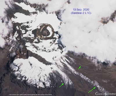
The image above was acquired by ESA's Sentinel-2 two days ago, revealing perhaps the least snowcover in several years. Such a view is especially valuable, as distinguishing between snow and ice on imagery is difficult. Clouds of course also complicate interpretation, and in this case case there are scattered clouds visible over the Northern Icefield's northern remnant, within the Breach on the west side, and over low-elevation portions of the southern glacier remnants. On visible portions of the south side, residual snow is estimated to comprise roughly half of the bright patches (i.e., non-glacier).

Noteworthy changes apparent in this image include on-going shrinkage of the Furtwängler Glacier (see above). The extent of south-side glaciers has clearly decreased, even acknowledging residual snowcover. At the Northern Icefield, the east end appears to have experienced the greatest change, due generally-thinner ice and a less-linear margin. In addition, several locations suggest that areas of anomalous geothermal heat are involved with ice loss, an ablation mechanism we have documented elsewhere at the summit. Further information on these new features will hopefully be forthcoming soon from Tanzanian collaborators.

Thursday, April 29, 2021

Late April snowcover


Satellite imagery of Kilimanjaro from the European Space Agency's Sentinel-2 is available every five days. Yesterday's nearly cloud-free image (28 April, above) and that from 23 April nicely bracket the time period when Tropical Cyclone JOBO approached the coast of Tanzania. On the 23rd, thick clouds obscured the mountain - except for the crater and a pie-shaped slice to the west, which are nicely visible.

Comparing these two images suggests essentially no snow accumulation on the mountain during the 5-day interval. The pattern of snowcover yesterday resembles that on the mountain since mid-January. Depth appears to have been thin at times when the snow-covered area was greater (i.e., following snowfall events). In general however, there currently appears to be less-than-average snowcover on the mountain, with another month remaining in the long-rains wet season (March-May).

It will be interesting to learn where the highest precipitation totals were recorded during JOBO.

For reference on the image above, Kibo Hut on the Marangu Route is visible within the orange circle (above), while the yellow ellipse highlights Barafu Camp. Trails leading toward the crater rim are faintly visible in both cases.


Thursday, November 12, 2020

Seasonal change

Snowcover within the Kibo caldera may have reached an annual minima last week. The two-image Sentinel-2 timelapse above shows the same area, five days apart.

The mostly cloud-free image on 4 November depicts the largest extent of snowfree area for calendar year 2020. Nonetheless, note the extensive snowcovered area east of the Northern Icefield and north of Reusch Crater; this was evidently an area of higher accumulation during the previous wet seasons. South of Reusch Crater, white areas within the caldera are all patches of snow - with the exception of one remaining fragment of Furtwängler Glacier, the east-west oriented body just south of the extensive snowfree area. On the caldera's south side, snowcover blankets the south-southwest facing slope and delineates the rim, closely paralleling the trail from Stella Point to Uhuru Peak. Encompassed within this area are the upper fragments of Kersten and Deckens Glaciers, with less-continuous snow around the Rebmann Glacier. Below the upper south-side glaciers is a steep, 100-150 m band without snow, then patchy snow and the snowcovered lower fragments of the Kersten and Deckens Glaciers.

Snow blankets the entire upper portion of the mountain on 9 November, as visible in the second image (despite a thin cloud veil). This snowfall event is "right on schedule" in terms of the precipitation climatology for high elevations of Kilimanjaro. This would be a fascinating time to be up there, for a survey of snow depth and spatial variability...

Sunday, October 25, 2020

Fires extinguished, snowcover continues to decrease

I hear from friends in Mweka that wildfires on the mountain are now out, thanks both to some rain, and hard work by personnel. They burned quite close to the Mweka (descent) trail, just above the upper forest line, a zone which has been severely impacted by fires and climate change in recent decades (see Andreas Hemp reference within this link). A helicopter pilot from Kenya was able to provide valuable assistance to firefighters for several days.

Today's satellite image - and that of 20 October - shows considerable cloud cover on the mountain, as expected at this time of year. A "hole" in the clouds does reveal the caldera's west side, and much of the Breach, to now be snowfree.

The next clear view of the mountain will be posted here. Will any seasonal snow persist to the next period of accumulation? Stay tuned!

Thursday, October 15, 2020

Serious wildfires continue [updated]


This morning's Sentinel-2 image of Kilimanjaro reveals the seriousness of fires burning since Sunday, high on the mountain (bands 12, 11, and 4). Reports suggest the fire was started accidentally along the Marangu Route. Early reports from TANAPA expressed premature optimism that "the fire is already under control" (14 Oct. via @tzparks), yet Minister of Natural Resources and Tourism, Hamisi Kigwangalla, is quoted in the NY Times today:  "the task is harder and bigger than it is thought to be".

On the false color image above, note the Reusch Crater. Snow and ice appear royal blue, with burning areas in yellow-red. This is a very serious, extensive fire! Smoke is visible being blown westward from the fires, burning at an elevation above 3000 m. The dominant vegetation type at this level is giant heather (Erica excelsa), which ecologist Andreas Hemp describes as "an obvious fire sign" which "enhances the fire risk, as even fresh Erica wood burns well". As highlighted in a UNEP posting based on Hemp's work, "nearly 15% of Kilimanjaro’s forest cover was destroyed by fire since 1976 and was replaced by Erica bush which extended its total area by 5km2 (mainly downslope)."

The upper portion of the popular Marangu Route is shown in green, passing Horombo Huts where some fire damage may have occurred. One updated account today (here) quotes Minister Kigwangalla as saying that yesterday's rebound "destroyed the Horombo Tourist Camp, including 12 huts, two toilets, and solar equipment". The mountain's primary descent route past Barafu Camp is also shown, appearing to be threatened by both fire and smoke.

We await first-hand reports from the mountain, and welcome any additional information.

[UPDATE 10/16:  Our friend Timba (Travel Consultant in Moshi) sent a link depicting Carbon Monoxide concentration, via the Earth website. Although the screenshot below does not show the data well, note the value for Kilimanjaro of 13,116 parts per billion by volume (high enough to cause chronic problems with long-term exposure - from CO alone).]


Tuesday, September 15, 2020

Processes in opposition

Ablation of seasonal snowcover continues at Kibo's summit, while hints of the forthcoming short rain season are becoming evident. The Sentinel-2 image above shows both continuing ablation since the end of August (see previous posts), and a dusting of new snow on southeastern slopes. This is also a nice illustration of how localized snowfall can be on the mountain.

Light accumulating snowfall is common at this time of year, as is its subsequent ablation within a few days. These opposing processes are especially critical for the glaciers as the dry season concludes, because albedo reaches an annual minimum while temperature, humidity, and solar radiation are all increasing.

In today's image (not shown), partially obscured by clouds, the dusting of snow seen above has completely ablated, and snowcover within the caldera is patchier yet.

While it appears that areas of snow will endure the dry season this year, failure of the short rains - or even a delayed onset - might yet ablate much of the lingering summit snow.