Showing posts with label friends. Show all posts

Saturday, November 11, 2023

October fieldwork!

We were back on the glaciers for fieldwork in October! As previously reported (here), the pandemic and logistical issues prevented us from visiting since February 2020, and although 'automated', our weather stations on the ice are not self-maintaining. Over the course of the ensuing three years, problems and damage occurred - so one of our objectives last month was to remove weather instrumentation and mass balance stakes. With tremendous help from the porters and staff of Summit Expeditions (SENE), we were successful. The next step is examining data we recovered, and evaluating options to continue measurements with new instrumentation!

Doug Hardy (UMass), Mike Winkler (GeoSphere Austria), and Emily Collier (Univ. Innsbruck). 

Click on any image to enlarge:

Fig. 1 (above): Kibo and 5,000 meters of relief, from Moshi. Preparing to head up again was very exciting, first time in over 3 years!

Fig. 2 (above): Our first task, led by Emily and her newly-funded research, was exploring the Kilimanjaro Mountain Club archives - in search of historical observations pertaining to the impacts of Tropical Cyclones on Kilimanjaro precipitation.

Fig. 3 (above): Morning of day two, a favorite view on the Umbwe Trail. These southern slopes were once covered by the Southern Icefield. Only fragments remain today, including sections of the Kersten Glacier (center).

Fig. 4 (above): Umbwe route passes through a recently-burned area below Barranco Camp, one of several new fire scars seen on this trip.

Fig. 5 (above): Diamond Glacier, Breach Icicle, and fragments of the Balletto Glacier. The icicle is larger than in 2020* due to meltwater drainage from above. Also note extensive rockfall onto the Balletto. (*2020 image here.)

Fig. 6 (above): Mike and Emily above Karanga Camp. Kersten Glacier remnants are visible above Mike, and the Rebmann Glacier is above Emily; between them is the vanishingly meager Decken Glacier ice.

Fig. 7 (above): Team member Mathayo Melio, preparing fresh greens (Kale) at Barafu Camp.

Fig. 8 (above): Late afternoon at Barafu, where multiple helicopter pickups are now occurring daily - typically to expedite the descent of wealthy clients.

Fig. 9 (above): Wishful thinking. Simon is testing whether he can transmit a message directly from his brain through this cable. Kilimanjaro Park authorities are testing whether they can string fiber optic cable along the trails for tourists to post on Instagram. We had no success with either. Increasing rockfall and debris flows on the mountain could make unprotected fiber maintenance difficult...

Fig. 10 (above): Riming on the Uhuru sign, as the weather clears. Northern Icefield in the distance.

Fig. 11 (above): Furtwängler Glacier from above. Since 2020 the area has decreased by seventy percent (yes, in 3 yearss); the glacier's demise is imminent.

Fig. 12 (above): Upper Kersten Glacier, October 2017; find the weather station. Zoom in, as this is a panorama. Then find the relatively thick, clean stratum and compare it's position to that in 2023 (next image).

Fig. 13 (above): Kersten Glacier upper margin, where thinning and lateral retreat continue. Where is the weather station? Occasional collapses of the wall and a marginal meltwater lake has been noted for 20+ years. However, compare the thick, clean ice layer position here with that 2017 (prior image) or in 2014, 9 years ago (with Will Gadd for scale).

Fig. 14 (above): Mike investigating ice blocks where the Kersten Glacier margin most-recently collapsed. Find the weather station (we couldn't either).

Fig. 15 (above): The largest remaining fragments of the former Eastern Icefield. The right-hand block is featured in the Red Bull film.

Fig. 16 (above): Northern Icefield margin, just west of camp. Note person for scale, just right of center - and the interesting basal stratigraphy.

Fig. 17 (above): Wonderful textures photo taken by Mike.

Fig. 18 (above): Northern Icefield margin, looking west toward camp. Compare to this similar view in February 2000.

Fig. 19 (above): Northern Icefield again... but the northern margin. As evident here, in next image, and elsewhere - the ice is fracturing to a greater extent than previously seen.

Fig. 20 (above): A fresh, curious collapse feature at the Northern Icefield margin. An ice layer associated with ponded and frozen supraglacial meltwater can be seen at the top of the fracture. These have been occasionally observed on Kibo's glaciers, always frozen at the surface.

Fig. 21 (above): A portion of AWS being carried through penitentes on the Northern Icefield. These particularly-large penitentes made walking difficult!

Fig. 22 (above): The AWS tower being carried back across the crater toward Uhuru Peak, 23 years after being brought up!

Fig. 23 (above): Doug, Emily, and Simon - along with about 20 other team members - prepare for a tree-planting ceremony honoring climate research on the mountain.

Fig. 24 (above): Final preparations for a feast celebrating safe and successful fieldwork! Much of this food was grown right on Simon's farm.
 

Thursday, October 12, 2023

Kibo Weather Stations - 23 years later


Our team is just back from difficult-but-stimulating fieldwork on summit glaciers, documenting Kibo's climate. Initial instrumentation at our weather station was installed in February 2000, then gradually supplemented and expanded. The configuration by 2013 is shown above. After near-annual maintenance and observation visits through 2017, we visited the stations for a Red Bull film in 2020 and then could not get back during the pandemic. Fieldwork in 2022 was foiled by bureaucratic miscommunication. By September of 2023, negative mass balance resulted in tipping and damage of equipment - the extent of which will soon be revealed by analysis of recorded data.

All the hardware, instrumentation, and ablation stakes have now been removed from the mountain and the National Park. As will be detailed in subsequent posts here, this was accomplished despite delays in departure, followed by high winds and riming precipitation. R
emoving everything required multiple trips to the summit by our accompanying crew, as well as an additional 19 porters to move equipment down the mountain.

We dedicate our 2023 mission to the hundreds of porters who have been essential to the success of this research since February 2000. They did the hard work transporting everything up - and then down - 5,000 meters of elevation, keeping us cheerful (most of the time) and productive. Perhaps most impressively, they were integral to a perfect safety record through the entire study. On this latest trip, we crossed paths with numerous porters from past trips, and spent time with one who was along on trip #1 back in February 2000; today he continues working as a respected mountain and safari guide. Also this month, one porter introduced himself as the son of a favorite porter, not yet born when his dad started helping. Asante sana to all the porters, guides, cooks, drivers, and support staff who have been involved - from Keys Hotel, Marangu Hotel, and since 2006, Summit Expeditions and Nomadic Experience (SENE).

2023 team:  Doug Hardy (UMass), Mike Winkler (GeoSphere Austria), and Emily Collier (Univ. Innsbruck)

Wednesday, October 27, 2021

The Big Climb

Good friend Simon Mtuy just returned from the mountain, following an effort to raise awareness of the need to fight the COVID-19 pandemic together. The Big Climb is raising funds to better track and understand the virus, equip health care workers, and to purchase vaccines for equitable distribution on the understanding that ‘no one is safe until everyone is safe’.

Simon is the perfect person to guide this talented, diverse group of 34 climbers up the mountain - including both young leaders, and accomplished all-star leaders. Who else but Simon could assemble such a group and compliment it with amazing ultrarunners Francesca Canepa, Maude Mathys, and Mira Rai* - wow! Also supporting the effort were the good folks at Marangu Hotel, with whom we have worked for nearly 20 years.

Check the impressive list of partners, and read more about everyone involved here!

  *Learn more about Mira here (US) or here (UK, EU?)


Caldera glimpse with decreased snowcover


Our most-recent fieldwork at Kilimanjaro summit was in February 2020, as the global pandemic began. Since then the mountain has been unusually quiet, with many guides and porters unemployed. They are as anxious as we are to get back up the mountain! Although satellite imagery allows us to assess some changes on the mountain, it is no substitute for on-site measurements and observations. Our reliable instrumentation on the Northern Icefield was functioning 18 months ago, yet the current status is unknown.

The image above was acquired by ESA's Sentinel-2 two days ago, revealing perhaps the least snowcover in several years. Such a view is especially valuable, as distinguishing between snow and ice on imagery is difficult. Clouds of course also complicate interpretation, and in this case case there are scattered clouds visible over the Northern Icefield's northern remnant, within the Breach on the west side, and over low-elevation portions of the southern glacier remnants. On visible portions of the south side, residual snow is estimated to comprise roughly half of the bright patches (i.e., non-glacier).

Noteworthy changes apparent in this image include on-going shrinkage of the Furtwängler Glacier (see above). The extent of south-side glaciers has clearly decreased, even acknowledging residual snowcover. At the Northern Icefield, the east end appears to have experienced the greatest change, due generally-thinner ice and a less-linear margin. In addition, several locations suggest that areas of anomalous geothermal heat are involved with ice loss, an ablation mechanism we have documented elsewhere at the summit. Further information on these new features will hopefully be forthcoming soon from Tanzanian collaborators.

Sunday, October 25, 2020

Fires extinguished, snowcover continues to decrease

I hear from friends in Mweka that wildfires on the mountain are now out, thanks both to some rain, and hard work by personnel. They burned quite close to the Mweka (descent) trail, just above the upper forest line, a zone which has been severely impacted by fires and climate change in recent decades (see Andreas Hemp reference within this link). A helicopter pilot from Kenya was able to provide valuable assistance to firefighters for several days.

Today's satellite image - and that of 20 October - shows considerable cloud cover on the mountain, as expected at this time of year. A "hole" in the clouds does reveal the caldera's west side, and much of the Breach, to now be snowfree.

The next clear view of the mountain will be posted here. Will any seasonal snow persist to the next period of accumulation? Stay tuned!

Wednesday, September 2, 2020

31 August snowcover

Snowcover continued to decrease during the last 5 days of August, as the image below reveals relative to that from 26 August (previous post). Change appears most evident in the northwest corner of the caldera. Nonetheless, the extent of snow at the summit remains more than average - with perhaps two months remaining in the extended dry season.

Tourism on the mountain remains minimal, as the new Coronavirus pandemic continues. For example, the Machame register book shows only 58 climbers departing for the normally-busy months of July and August.

Our friend Simon Mtuy and a large SENE team have been assisting in a large clean-up operation. Over just two days, SENE staff collected 45 kilos of trash from the Machame Camp area. Simon reports that this week there will be 400 crew from 16 companies helping in the clean-up, which will include the Western Breach route and the Crater Camp area. Asante sana!


Tuesday, June 9, 2020

AWS, long rains end, quiet mountain


Our friend Simon (SENE*) made a trip to the summit caldera recently, and has shared some photos. He kindly detoured his climb to visit the Northern Icefield AWS and inspect our instrumentation. The upper photo illustrates snowcover on the glacier at the end of February. The red circle highlights a replacement temperature/humidity sensor, which with luck is accurately measuring these important variables again.

The second image shows a net 'long-rains' snow accumulation of at least 50 cm. Aside from footprints, the surface texture suggests that a week or more has passed since the last snowfall. On the ascent, Simon estimates ~60 cm of snow beginning
below the caldera rim.

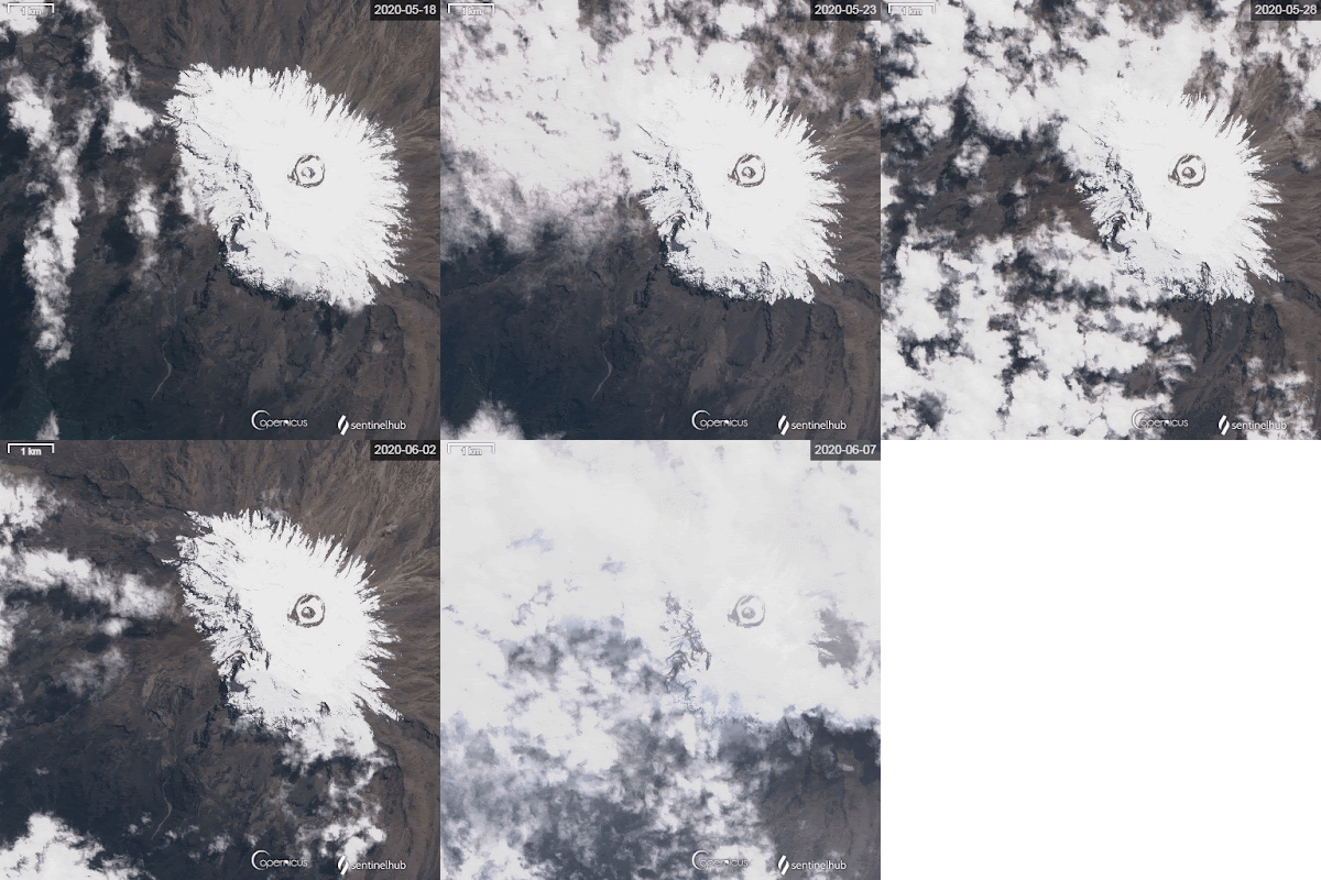
Below is a Sentinel-2 timelapse of snowcover between 18 May and 7 June. The transient snowline can be seen increasing in elevation, with thinning of snow on north-facing slopes. This pattern of ablation will likely continue in the months ahead, as rarely does the 'long-rains' season extend much into June.

Simon reports that the
mountain is currently devoid of people. In the lower right-hand corner of the satellite image is a light-colored, circular area, which is "Barafu Camp" at 4,700 m. This is the last camp used by most climbers, and once the dry season gets underway it is bustling with hundreds of people. The lowest photo shows Barafu this year, with not a single tent visible; only camp infrastructure buildings can be seen.

*Tourism is severely impacting Tanzania, as the case with other destinations reliant upon international tourism. In preparation for a return to something approaching normal, SENE is offering special terms for future trips booked during June - safaris as well as Kilimanjaro climbs.  #TravelTomorrow 


Tanzania's President Magufuli has taken drastic steps to reopen the country, lifting the ban on flights and removing the required quarantine. Time will tell whether this early action was responsible...


Wednesday, April 29, 2020

Ski Africa!


From a satellite's perspective, Kilimanjaro emerged from thick cloud cover yesterday, revealing substantial snow blanketing the upper ~1300 m of the entire mountain (i.e., above about 4600 m / 15,100 ft). This is an area of ~50 km^2.

Distinguishing between fresh snow and thin, low clouds is difficult on this particular image - yet snowcover appears remarkably uniform. On such a big mountain, precipitation often varies spatially, reflecting interaction of the massif with regional circulation.

Not often is it possible to ski 1000+ meters at 3° south latitude. But if snow accumulation continues through May, as it typically does, t
his June might be a great time to ski the mountain - with appropriate COVID-19 precautions.

#seneadventures
@christianpondella

Tuesday, April 14, 2020

April Update

Northern Icefield margin with "cloudcam" and AWS. At the edge, note the layer of seasonal snow overlying glacier ice (23 February 2020).
Mid-April is typically not a busy time on Kilimanjaro, midway through the so-called "low season" when climbers avoid what are often the wettest months, associated with widespread convection. However, April this year is unusually quiet, due to the global pandemic; as with National Parks around the world, Kilimanjaro is devoid of human visitors. Schools are closed, and residents are sheltering in place - many without employment. For a region so dependent upon tourism and foreign exchange, this is a devastating time. We empathize with guides and all the other mountain staff who eagerly await the return of clients, and the opportunity to share their mountain with visitors.

Since the short rains diminished in January, a series of snowfall events have maintained fresh snowcover on the glaciers (see images above and below). Summit caldera snowcover has varied between continuous (see 3 Feb image) and patchy (as seen on yesterday's satellite image, above). Snowcover appears to have been gradually decreasing over the past two weeks, as also occurred during February until restored by early March snow.

In most years the long rains continue through May, ending rather abruptly by early June. Precipitation between now and then will determine what climbers encounter once travel and group climbs are safe again. Although recession of the glaciers continues, seasonal snowcover creates an illusion of permanence. At some point during the dry season though (June-September), the snow is likely to completely ablate and the bright ice will again be in stark contrast to the dark volcanic ash - reminding us that the ice will likely be gone within a few decades.


Residual ice with Mawenzi in the background. Note seasonal snow layer on the ice as well as the crater surface (25 February 2020).

Monday, February 3, 2020

Stable weather returns [updated]


February weather on Kilimanjaro is often characterized by a dry interval, between the Short Rains of approximately Nov/Dec, and Long Rains within the Mar/Apr/May time period. As noted previously, the Short Rains brought considerable rain to the mountain this year, with snow up high, beginning in early October. That wet period appears to have ended.

The upper image from 2 February shows patchy snowcover on the upper 1000 meters of the mountain's south side, as viewed from above Moshi (Simon Mtuy credit). Distinguishing remnants of the former Southern Icefield from snowcover is difficult here.

The second image above was acquired today by the ESA Sentinel-2 satellite, revealing continuous snowcover within the summit caldera, and on the upper slopes. The stable-weather cumulus clouds visible here appear only slightly more extensive than those on the day before (top image).

Although telemetry of data from the Northern Icefield (NIF) weather station is not currently available (budget constraints), several recent reports from climbers confirm what the images depict. On 23 January, collaborator Sarah Konrad visited the NIF and measured a mean snowdepth of ~0.60 m around the weather station. Shortly thereafter (28 Jan.), Simon was above the Western Breach in the Furtwängler Glacier area, reporting "almost one meter of snow."

Images below show Simon's camp at Arrow Glacier on the 27th, looking south across the Western Breach, and a Furtwängler Glacier remnant near Crater Camp (Sarah Konrad credit). Finally, a photo of the NIF weather station from Sarah reveals that the equipment is overdue for a "service visit". Fortunately, planning is underway to visit the station later this month!


[UPDATE 02/04:  Our friend Timba keeps close tabs on Kilimanjaro weather from Moshi, in the interest of safety for the many guides and porters working on the mountain. It was Timba who inspired our analysis of how tropical cyclones might influence snowfall on the mountain (Collier et al., 2019).

Timba wrote today, emphasizing how wet the region has been in recent months, especially at the end of September and through most of October 2019. As he points out, this is the time when the
Indian Ocean Dipole (IOD) was very strongly positive, a water temperature pattern associated with heavy rain in eastern Africa - and bushfires in Australia (read more here and here).

So, has stable weather really returned to Kilimanjaro? Although the IOD has returned to a neutral pattern, older friends of Timba's equate the current rainfall pattern with that of Oct. 1988 to June 1989 - when the two rainy seasons merged into one long wet season.]


Tuesday, December 3, 2019

More Snow

The wet 2019 short rains continue, according to both satellite imagery and reports from the Kilimanjaro region. Simon Mtuy wrote today that the mountain has been in clouds for the past three days, with heavy rain last night.

Above is a glimpse of the mountain two hours ago, from TPC sugar plantations (above Moshi).

Active convection continues over the anomalously-warm, western Indian Ocean. Tropical Cyclone 06A is forecast to move southwest to Somalia on a track toward Lake Victoria, with landfall on 6 December bringing heavy rainfall and high winds; not what eastern Africa needs this year.


In addition to cyclone 06A, another cyclone is forming on the other side of the Equator. Rarely do cyclones form on both sides (circulating in opposite directions). Read more about this situation, and the vigorous convection expected, here. [credit Severe Weather Europe]


Sunday, October 27, 2019

Early short-rain snow

Snow conditions on Kibo have changed considerably over the past 10 days, as shown in the timelapse above. Very little seasonal snow was present on 16 October, nicely revealing the current distribution of glacier ice. Five days later the entire summit was blanketed by snow. A second-hand report from our friend Simon Mtuy indicates that the snowline on the 18th was below Kibo hut. (Simon's wonderful company is SENE).

Between the 21st and 26th, ablation of new snow appears to have dominated over additional accumulation. However, note extensive snow below the Western Breach on the 26 October image; this may have resulted from localized convection, typical on that side of the mountain. Simon was on the mountain last week, so it will be interesting to hear his observations. Low on the mountain (i.e., below 1800 m) he reports nearly non-stop rain since the beginning of October - an early beginning to the short-rains season!

Saturday, April 6, 2019

South-side glacier changes


The images above depict how Kibo's south-side glaciers have changed in area and thickness over the past 13 years. Thanks to Catrin Stadelmann and her advisor Thomas Mölg for sharing them (Friedrich-Alexander-University (FAU) in Erlangen-Nürnberg, Germany).

Note that both snow and ice are visible in these images, particularly the lower one (Jan. 2019). The largest glacier shown is the Kersten, which Dr. Mölg has published extensively on. Shortly after 2006, a gap began widening between the upper ice and the steeper slope portion of the Kersten. Similarly, a gap also formed between the Kersten and the Decken Glacier to the east (right-hand side of the Kersten). The Decken has gradually narrowed, and very little ice remains today. On the Kersten's left (western) side, remains of the Heim Glacier are visible in 2006; the lower-most extent of this glacier was still present by 2019, surrounded by considerable transient snowcover in the image above.

Tuesday, February 26, 2019

19 years on the Northern Icefield


This week marks 19 years since AWS measurements began on Kilimanjaro's Northern Icefield (NIF). With enthusiastic help from our Tanzanian crew, Mathias Vuille and I installed a tower into the ice and connected the electronics. Remarkably, the same datalogger continues measurement and control functions, and the same solar panels continue to provide power. Most sensors have been swapped out for recalibration or replacement, yet the original barometric pressure sensor continues reliable measurements every hour.

Ice ablation since 2000 has substantially reduce the areal extent of all glaciers on the mountain. However, this portion of the NIF has "only" thinned by ~5 meters, because the low surface gradient retards meltwater runoff - which then refreezes in place as superimposed ice. Other portions of the NIF, and other glaciers, have thinned more dramatically. For example, ice no longer remains at February 2000 drill sites on the Furtwängler and Decken Glaciers, which were 9.5 and ~20 m thick at the time (respectively).


Wednesday, November 7, 2018

Wild weather on the mountain


Fieldwork is an essential component of climate and glacier research, providing basic measurements as well as a foundation for theoretical and modeling studies. Yes, fieldwork can be tremendously fun, sometimes even yielding unexpected discoveries – yet it can also be difficult and dangerous. A successful fieldwork campaign requires alignment of numerous components and factors; some of these we can control, and others we must manage. For both categories, past experience and planning is helpful. Sometimes though, the outcome also requires good luck.

After 20 prior trips to my AWS on Kilimanjaro’s Northern Icefield, plans for October fieldwork came together within only a couple weeks. Telemetry of data revealed technical problems which could only be resolved by a visit to the station. However, budgetary constraints dictated that this trip would need to be done differently. While recognizing that a lighter and faster approach would reduce the factors we could control, and increase the required management of other factors, we decided that the potential rewards of a brief visit to the station outweighed the risks of this strategy. Supportive and generous collaborators* agreed to make the visit possible.

Our quickly-hatched plan was to acclimatize normally, and then in one day ascend the final 1000 meters, undertake 4-6 hours of work, cross the summit caldera, and descend the other side to rejoin our support team. Past experience on the mountain suggested to all involved that the concept was reasonable –given just a few hours of reasonable weather. For this trip, ‘reasonable’ weather meant conditions under which an ascent of the Western Breach was safe (i.e., cold and dry), followed by a few hours at the AWS without heavy snowfall, wind less than ~20 km/hr, and air temperature above -5 °C or so; any sun would be a bonus. Once finished at the station, we were confident about descending in almost any conditions.

Reasonable weather prevailed through our first two days on the mountain, followed by conditions more typical of the wet seasons (e.g., April-May). Warmth, rain, and wind appeared in the forecasts, and on day 3 became our reality on the mountain, conditions increasingly at odds with both our work needs and those required for the safety of all involved. Ascending in wind-driven rain to Arrow Glacier camp below the Western Breach, there was little ambiguity about what we were likely to encounter the following day – which proved accurate, as illustrated below and revealed by telemetry from the AWS. That afternoon a consensus emerged: continuing with our plan would unacceptably compromise safety, and that work at the AWS would almost certainly be impossible.

Disappointing? Absolutely. Station problems remain unresolved, and the 18-year nearly-continuous record may be compromised. In addition, not measuring and documenting the summit glaciers will prevent assessing the response of anomalous accumulation during the 2018 long rains. Furthermore, any compromise on fieldwork goals is disappointing in light of the carbon cost of traveling nearly 30,000 km. However, our decision to retreat was correct, for in contrast to several other groups on the mountain, we all returned safely.

Field scientists must fully exploit observational and quantitative opportunities during every moment in the field, and learn from every experience. This trip provided new insight into the development of weather systems on Kilimanjaro. Valuable photographs and observations of the slope glaciers were obtained, and new understandings were gained through interactions with others on the mountain. More difficult to accept was something we already knew, the false economy of an ambitious undertaking in too-little time. Future fieldwork must allow adequate time to accommodate difficult weather conditions, despite the higher financial cost of extended fieldwork time on Kilimanjaro summit glaciers (e.g., extra Park fees, staff salary premiums). Finally, the experience highlights the value of high-elevation climate and glacier data, which should never be taken for granted.

*Special thanks to Nicolas J. Cullen at University of Otago (New Zealand), and Thomas Mölg at Friedrich-Alexander-University (FAU) in Germany, for their encouragement and vital support!

Fig. 1. Timelapse of clouds over Kibo, 24 Oct. at 13:30 (~1 sec interval). Wind speeds began increasing on the 23rd, and remained high for 3-4 days. Airflow throughout our time on the mountain was from just south of east, as illustrated in Fig. 3 below.

Fig. 2. Kibo on 24 Oct. at 13:30 from near Karanga Camp. Although the mountain is quite snowy for mid-October, snowcover decreased during the days prior, due to rain and a high freezing level (note lack of fresh snow east of the Rebmann Glacier, on right-hand side of image).

Fig. 3. Airflow and relative humidity at 500 hPa over east Africa and Kilimanjaro (green circle), 24 Oct. at 14:00. Cyan color indicates RH above ~95%; 49 km/hr equates to ~30 MPH, not a particularly high windspeed for a mountain summit, but difficult to work in when humidity is high (see riming in Fig. 4). Source: earth.nullschool.net (c) 2018 Cameron Beccario.

Fig. 4. Summit scenes early on 25 Oct., when apparently only 2 Norwegians and their guide reached the top. Photos courtesy of Dismas Kishingo, via Emanuel Mutta of SENE.

Fig. 5. Landsat 8 scene from 28 Oct. at 10:43 local time. Fresh snow on Kibo and Mawenzi accumulated over the prior ~4 days, when AWS data show dropping air temperature and 20+ cm of accumulation.


Fig. 6. The proverbial calm after the storm. Kibo as seen from Moshi, 28 October at 08:00 (just prior to the Landsat image above).